Showing posts with label wk7. Show all posts

Wednesday, February 25, 2009

TPACK Questions for Virtual Tour

What is the content you’ll be using in your lesson?

The content that I will be using for my lesson is found in the Utah state core curriculum for 4th grade. It is under Standard 3, Objective 1, c which states "Sort rocks by appearance according to the three basic types: sedimentary, igneous and metamorphic (e.g., sedimentary–rounded-appearing mineral and rock particles that are cemented together, often in layers; igneous–with or without observable crystals that are not in layers or with or without air holes or glasslike; metamorphic –crystals/minerals, often in layers)." I remember having to memorize rocks for a class I recently took and was disappointed that my teacher could not come up with an interesting and fun way to have us learn and remember these rock names. I feel like this activity with GoogleEarth will help students become excited about learning about rocks.

What is the pedagogy you’ll be using and why is it a good fit with the content?

I am using good pedagogy by selecting content that is normally hard to understand and unclear of the importance of it. My students will be using classification, researching, comparing as well as contrasting the three different types of rocks. I feel like since the students have first been given an overview of the different rocks they will benefit more from exploring the rocks and where they are formed themselves.

What is the technology you’ll be using and why is it a good fit with the content and pedagogy?

The technology I will be using for this lesson is Google Earth as well as images from online sources and information accessible from Wikipedia. I feel like GoogleEarth is a good fit for the content because it enables students to see real life examples of rocks and how rocks are formed and where they are formed. The students can see the rocks in different areas and compare and contrast the characteristics of the rocks as well as the areas that they are looking at. No other tool that I know of allows people to view real life areas on a zoomed in scale at street view. Students can see so much of what they are learning now, instead of having to rely on maps and pictures. They can go there through GoogleEarth and see the areas. GoogleEarth is an exciting tool that students will love.

Virtual Tour Plan

Location ActivityGoogle Earth Content
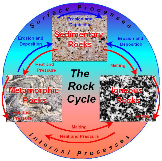
1.West Indies (igneous)Briefly introduce the rock cycle and explain that they will see places where all 3 parts occur. Have students reach the location on GoogleEarth. Ask the students what type of rock is formed at the volcano they see at Mount Rausu; discuss what happens in forming igneous rocks. Then have them watch the igneous rock video at
http://activities.macmillanmh.com/science/c
a/scienceinmotion/Common/SIM.html?Module=../Grade4/Chapter3-IgneousRockFormation/Then have the students look at pictures of various igneous rocks.

Panoramio

Terrain Feature

Lables

Pathway

2.Grand Canyon, Arizona (sedimentary)Have students reach the location on GoogleEarth. Teacher will explain process of forming sedimentary rocks. Have them watch the sedimentary rock video at
http://activities.macmillanmh.com/science/c
a/scienceinmotion/Common/SIM.html?Module=../Grade4/Chapter3-IgneousRockFormation/
Have students look at pictures of various sedimentary rocks
Panoramio
Terrain Feature
Lables
Pathway
3.Maunola, Hawaii (metamorphic)Have students reach the location on GoogleEarth. Teacher will explain process of forming metamorphic rocks. Have them watch the metamorphic rock video at
http://activities.macmillanmh.com/science/c
a/scienceinmotion/Common/SIM.html?Module=../Grade4/Chapter3-IgneousRockFormation/Have students look at pictures of various metamorphic rock
Panoramio
Terrain Feature
Lables
Pathway
4.Karnataka, India (sedimentary)Have students reach the location on GoogleEarth. Have students explore this area using the zoom features and others available to identify at least one type of rock in the area. Once students identified one rock formation have students explore other locations and the rocks there.Panoramio
Terrain Feature
Lables
Pathway
Details of image overlay / path / polygon:In our Google tour we used the Geographic web features of Panoramio. We also used the terrain feature, and labels so the students would know what they were actually looking at. Our tour began at Mount Rausu, Japan, it then went to the Grand Canyon, Arizona, next it went to Manualoa, Hawaii, and finally to Karnataka, India. The path shows the travel route to each location.
SOURCES:
Igneous Rock Formation:http://www.outreach.canterbury.ac.nz/resources/geology/glossary/igneous.jpg
Three Types of Rock Formation:http://i.ehow.com/images/GlobalPhoto/Articles/2281951/RockCycle-main_Full.jpg
The Rock Cycle:http://web.ics.purdue.edu/~braile/edumod/pebble/pebbleAM_files/image007.jpg
Sedimentary Rock Formation:http://www.energyinst.org.uk/education/glossary/images/sediment.gif
Metamorphic Rock Formation:http://www.bbc.co.uk/schools/ks3bitesize/science/images/sci_dia_33.gif
Metamorphic Rocks:http://honolulu.hawaii.edu/distance/geolab/R*M/metrx.jpg
Igneous Rocks:http://honolulu.hawaii.edu/distance/geolab/R*M/metrx.jpg
Sedimentary Rocks:http://honolulu.hawaii.edu/distance/geolab/R*M/sedrx.jpg